Heritage & Hiking Guide · 1 September 2026 · 11 min read
The stone bridges of Zagori: a walking guide through history
From the triple arches of Plakida to the quiet ravine crossing at Misiou, Zagori's Ottoman-era stone bridges turn a walk between mountain villages into a tour through 250 years of vernacular engineering — no ticket required.
There's a moment on the old path between Kipi and Koukouli when the forest opens and you see it for the first time — three graceful stone arches leaping over a ravine, moss creeping up the lower stones, the river threading beneath like silver. That's the Plakida Bridge, built in 1814 and still carrying foot traffic more than two centuries later. Welcome to Zagori, where walking is time travel.
This guide covers the four stone bridges you shouldn't miss — Plakida, Kokkoris, Misiou and Kleidonia — what's actually documented about who built them and when, the hiking circuit that links them, and how to fit them into a wider trip through the Vikos Gorge and Papigo.
Why these bridges matter
Scattered across the ravines and river gorges of Epirus, the stone arch bridges of Zagori are among the most remarkable examples of vernacular engineering in Greece. Most were built between the late 17th and the 19th century, financed by local monasteries, merchants and village benefactors, to connect the 46 villages of the Zagorochoria across terrain that was — and still is — spectacularly unforgiving. Deep gorges, seasonal torrents and mountain passes that snow shuts for months each winter made these crossings lifelines rather than luxuries.
The builders belonged to an itinerant craft tradition centred on Epirus, working in single-, double- and triple-arch designs using only local stone and lime mortar — no reinforcing steel, no concrete. Just geometry, gravity and knowledge passed down through generations of masons.
In 2023, UNESCO's World Heritage Committee inscribed the Zagori Cultural Landscape — its villages, footpaths, forests and bridges together — as a World Heritage Site, recognising the whole interconnected network rather than any single monument. Counts of surviving bridges vary by source, but a commonly cited figure puts around 60 still standing in good repair today, out of well over 100 believed to have been built across the wider area before floods, abandonment and modern roads took their toll on the rest. The finest surviving examples cluster in the triangle formed by Kipi, Koukouli and Dilofo, and a single hiking route links the four described below.
Plakida (Kalogeriko) Bridge
The showstopper. This triple-arched bridge near Kipi is the most photographed in Zagori, its three arches of graduated size spanning a tributary of the Voidomatis with a symmetry that feels almost musical. It was built in 1814, commissioned by Abbot Serafeim of the nearby Monastery of Prophet Elias in Vitsa to replace an older wooden crossing — "Kalogeriko" simply means "of the monk" in Greek, a nod to the abbot rather than a family surname. The bridge later picked up its more common name after a repair funded by Alexis Plakidas in 1863.
The central arch rises highest, flanked by two smaller arches that carry overflow water during spring melt and anchor the whole structure visually. Come in the morning when the light slants through the arches, or in autumn when the surrounding plane trees turn amber. There's a small parking area nearby if you're driving, but arriving on foot from Koukouli is more rewarding.
Kokkoris (Noutsos) Bridge
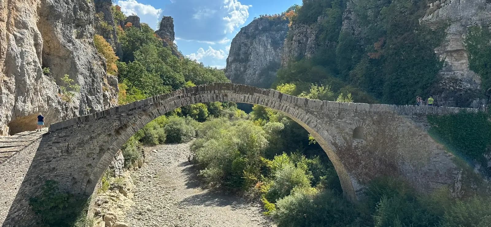
If Plakida is the elegant one, Kokkoris is the dramatic one. A single high arch spans a deep, narrow ravine between Kipi and Koukouli, and standing on it you look straight down into a gorge that drops away with real verticality. It's generally dated to 1750, when local benefactor Noutsos Kontodimos financed the original construction — though the record isn't perfectly clean: one surviving inscription gives a slightly different year, and at least one 19th-century historian attributed an earlier version of the bridge to a different backer altogether. What's well documented is a later repair: in 1910, a miller from Koukouli named Grigoris Kokkoris paid for restoration work, and the bridge has carried his name alongside the older Noutsos name ever since.
It's smaller and more remote-feeling than Plakida, reached by a footpath that descends steeply through oak forest. The approach is half the experience — you hear the river echoing off the gorge walls before you see the bridge itself.
Misiou Bridge
Less visited than its neighbours but arguably the most atmospheric, Misiou is a double-arched bridge on the old path linking Vitsa, Koukouli and Monodendri (older sources sometimes spell the name Misios). It was built in 1748 and funded by Alexis Misios, a local dignitary from Monodendri who gave the bridge its name — making it, by most accounts, one of the oldest surviving bridges in the cluster. Some tourist material describes it as a single arch; the double-arch design and the Vitsa–Monodendri connection are what the more detailed historical sources agree on.
The setting is deeply quiet — just birdsong, running water and the creak of old oaks. If you're walking the wider circuit and want to detour via Misiou rather than sticking strictly to the Kipi–Koukouli–Dilofo triangle, it's a rewarding add-on and a good spot to stop for lunch by the water below the arch.
Kleidonia (Voidomatis) Bridge
Kleidonia is the odd one out on this list — not clustered with the other three, but a short drive further north on the road between Kipi and Kleidonia village, where a single wide arch carries the road over the Voidomatis River. It was built in 1853, funded by Balkiz Hanum, wife of the Ottoman official Malik Pasha, at a reported cost of 37,000 piastres. It replaced an older bridge from Byzantine times at the same crossing — one tied, according to local tradition, to a blood feud between two families so severe it's said to have led to an entire village being abandoned.
What the bridge spans matters as much as the bridge itself: the Voidomatis here runs through a stretch regularly cited as among the cleanest river water in Europe, and on a sunny day the pools beneath the arch turn an almost unreal shade of turquoise. Unlike the other three bridges on this list, Kleidonia sits right beside the road, which makes it easy to reach by car and a natural first or last stop on a bridge-focused day.
It's also the connector: Kleidonia marks the point where the bridge network meets the wider Vikos Gorge and Voidomatis River trail system, and hikers moving between the gorge, the river and the villages typically cross here at some point. For the hiking routes that start or finish at Kleidonia, the river's swimming spots, and the Ice Age Trail along the Voidomatis, see our dedicated guides to the Vikos Gorge hike and the Voidomatis River below — this page covers the bridge itself.
The hiking circuit: the Stone Bridges Trail
The classic way to see Plakida, Kokkoris and the villages around them is on foot, following what's usually called the Stone Bridges Trail — a loop connecting Kipi, Koukouli and, in longer versions, Dilofo and Vitsa. Reported distances vary quite a bit depending on the source and which villages you include: the shortest published loop (Kipi and four bridges) runs about 8.6 km, while versions extended through Dilofo and Vitsa stretch to around 11–12 km. If you see very different numbers from different tour operators, that's why — check exactly which villages a given route covers before you commit to a duration.
Most guided-tour operators rate the core loop as easy to moderate rather than genuinely hard, suitable for reasonably fit walkers without technical hiking experience — though don't underestimate it: the descents into the ravines to reach Kokkoris and Misiou are steep, as are the climbs back out, and the surface is uneven kalderimi rather than a graded path.
The route follows a mix of old kalderimi — the original cobbled mule paths that connected the villages — and forest trails through oak and beech, with wildflowers carpeting the clearings in spring. Trail marking is inconsistent: expect old, sometimes faded red paint blazes rather than a modern waymarked system, so download a GPS track or offline map rather than relying on markers alone.
Carry all the water you expect to need — village fountains exist along the way, but don't plan around them as your main supply. Wear proper hiking boots rather than sandals, and start early in summer to avoid the midday heat on the exposed sections.
| Distance | ≈8.6 km for the short Kipi loop; up to ~12 km extended through Dilofo and Vitsa |
| Duration | 4–5 hours at a comfortable pace |
| Difficulty | Easy to moderate (short, steep descents/climbs into the ravines) |
| Start/End | Kipi (most published routes start and end here) |
| Trail markings | Old, patchy red paint blazes on the kalderimi — carry a GPS track or offline map |
Visiting by car
You don't need to hike to enjoy these bridges. Kipi is the natural base — the largest of the cluster villages, with guesthouses and tavernas — and from there Plakida is about five minutes by car. Kleidonia is roughly 15 minutes away on the road toward the Voidomatis.
Kokkoris and Misiou both sit in ravines, so there's no driving all the way to either — park at the marked trailheads and expect a 10–20 minute walk down (and, worth remembering, back up) to reach them. A relaxed half-day by car can comfortably cover all four bridges.
Combining with Vikos Gorge, the Voidomatis and Papigo
The bridges sit at the southern edge of the Vikos Gorge — one of the deepest gorges in the world relative to its width — and combining the two is the obvious move for anyone spending more than a day in Zagori. Kleidonia Bridge is the natural link between the two: hikers doing the classic Vikos Gorge route, or a shorter stretch along the Voidomatis, typically pass through here.
Papigo — actually two villages, Megalo and Mikro Papigo — sits on the northern side of the gorge and makes a good two- or three-night base for combining the bridges, gorge hiking and the natural rock pools further up the valley. A realistic itinerary: day one, arrive and walk the Stone Bridges Trail from Kipi; day two, transfer to Papigo and hike into the gorge or out to a viewpoint; day three, a morning swim before heading on.
Getting there from Preveza (PVK)
Preveza's Aktion Airport (PVK) is the gateway most Ionian-coast travellers will use, and Kipi is a little under 3 hours' drive away, following the same route as the rest of Zagori — north past the Ambracian Gulf to Ioannina, then on into the mountains. For the full drive breakdown, road conditions and where to base a campervan, see our dedicated Zagori & Vikos Gorge guide, linked below.
There's no practical public transport to the bridge villages — a bus reaches Ioannina, but onward services to Kipi, Koukouli and Dilofo are infrequent at best. Renting a car or campervan at PVK is the realistic option.
Final thoughts
The bridges of Zagori aren't museums. They're not roped off, ticketed or explained by audio guides — they're simply there, in the ravines, spanning the rivers, doing what they've done for two centuries. That's what makes walking among them feel less like sightseeing and more like joining something already in progress. Lace up, pack water, and step onto the old stones.
Keep planning your trip
- Zagori & Vikos Gorge from PVK: campervan logistics, driving and where to stay
- Hiking the Vikos Gorge: routes, distances and what to expect
- The Voidomatis River: swimming, rafting and the Ice Age Trail
- The Ovires natural pools near Papigo
Planning a trip to the stone bridges of Zagori?
Kipi, Koukouli and the rest of the bridge villages sit deep in the mountains — a campervan gives you the freedom to base yourself locally rather than day-tripping from the coast. Browse our fleet to find one suited to Zagori's narrower roads.
Join the Waitlist